
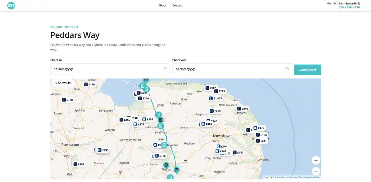
Self Guided Travel introduces interactive trail and accommodation maps
Self Guided Travel has begun introducing interactive maps that bring together long-distance walking routes and accommodation in a single planning tool.
The maps display the GPX route of a trail alongside places to stay, allowing walkers to explore accommodation in the context of the route rather than on a separate, generic accommodation map.
The Peddars Way is one of the first trails to use the new system, with its complete 46-mile / 74 km route displayed alongside accommodation in and around the places it passes through.
Seeing accommodation in relation to the trail
Where accommodation is located can be particularly important when planning a multi-day walk.
Villages, daily distances and the availability of places to stay can all influence where a walking day begins and ends.
By displaying the trail itself on the accommodation map, walkers can see how individual properties relate to the route and the surrounding destinations.
They can explore different parts of the trail, select accommodation and continue to a booking page to check availability and make their own reservation.
The map is intended as a planning tool rather than a fixed itinerary, allowing walkers to decide which places and distances work for their own journey.
Using GPX data to connect routes and places
The system uses GPX route data published by Self Guided Travel and connects it with live accommodation mapping.
For the Peddars Way, this means the route from Knettishall Heath to Holme-next-the-Sea can be viewed alongside accommodation around places such as Great Cressingham, Castle Acre, Great Massingham, Ringstead and the Norfolk Coast.
This creates another connection between the different parts of Self Guided Travel: Trails, Destinations, Stays, Journeys and practical Guides can all contribute to planning the same journey.
Walkers can also download the GPX route separately where it is available for use with their own navigation tools.
Supporting independent journey planning
The maps form part of Self Guided Travel's approach to helping people research and plan journeys independently.
A walker might begin by discovering a trail, investigate the landscapes and places along it, use the map to understand accommodation options and then use practical Guides to work out how to reach the start or travel home.
Alternatively, suggested Journeys provide a starting itinerary that can then be adapted.
The aim is not to prescribe how a trail should be walked, but to bring together enough useful information for travellers to make those decisions themselves.
Expanding the maps across Self Guided Travel
The Peddars Way is an early example of the system, with interactive trail and accommodation maps planned for more of the long-distance routes published by Self Guided Travel.
As the system expands, GPX routes will help connect accommodation with the trails, landscapes and destinations around them.
This is particularly useful in rural areas, where the relationship between a place to stay and the route or landscape being explored can be as important as the accommodation itself.
The interactive maps will become part of Self Guided Travel's continuing work to publish Britain's trails, landscapes and wild places, and provide practical tools for planning independent journeys through them.
.webp)