
Riverside walks, tidal landscapes and Suffolk's maritime heritage
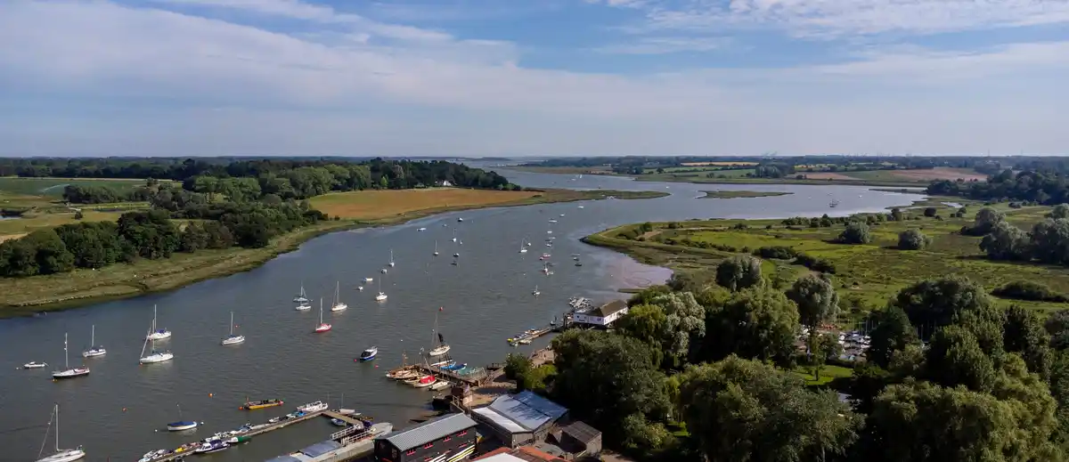
The River Deben flows through the countryside of east Suffolk, rising near Debenham before passing through farmland and rural villages towards Woodbridge, where it becomes a broad tidal estuary. Its lower reaches form part of the Suffolk & Essex Coast & Heaths National Landscape, characterised by saltmarshes, mudflats, wooded riverbanks, traditional boatyards and historic settlements.
Woodbridge is one of the principal settlements along the river, with a long history of boatbuilding, maritime trade and sailing. Its waterfront is home to Woodbridge Tide Mill, a historic tidal mill overlooking the estuary, alongside boatyards, moorings and riverside paths. Walks along the river offer views across the tidal waters towards the wooded slopes and open countryside surrounding Sutton Hoo.
On the eastern side of the river, Sutton Hoo is one of Britain's most significant archaeological sites, renowned for its Anglo-Saxon royal burial mounds and remarkable archaeological discoveries. Its elevated position above the Deben reflects the historical importance of the river as a connection between inland settlements and the North Sea.
Further downstream, the landscape opens into a broad estuary bordered by grazing marshes, farmland and extensive areas of intertidal mudflat. Small riverside settlements, including Waldringfield and Ramsholt, retain strong connections with the river, with traditional inns, sailing facilities and footpaths overlooking the water.
The Deben Estuary is internationally important for its wildlife and is designated as both a Special Protection Area (SPA) and a Ramsar wetland site. Its saltmarshes and tidal mudflats provide valuable feeding and resting grounds for wading birds and wildfowl, including avocets, redshanks, curlews and dark-bellied brent geese. The changing tides continually reshape the appearance of the estuary, exposing extensive mudflats at low tide before filling the channels and creeks.
At the mouth of the river, Felixstowe Ferry and Bawdsey sit on opposite banks of the estuary. A seasonal passenger ferry connects the two settlements, continuing a long tradition of river crossings and providing a link for walkers and cyclists exploring the Suffolk coast. The surrounding landscape is characterised by shingle beaches, fishing boats, sailing vessels and wide views across the North Sea.
The Suffolk Coast Path and the King Charles III England Coast Path connect the River Deben with the wider Suffolk coastline. The seasonal ferry between Felixstowe Ferry and Bawdsey provides a crossing at the mouth of the estuary. From Felixstowe Ferry, walkers can follow the coastline south towards Felixstowe, continuing along the seafront towards Landguard Point and Landguard Nature Reserve. On the opposite bank, coastal paths lead through the countryside beyond Bawdsey towards Shingle Street and the wider landscapes of the Suffolk coast.
Shorter walks can be enjoyed around Woodbridge, Waldringfield, Ramsholt and Felixstowe Ferry, combining riverside scenery with historic buildings, traditional pubs and maritime heritage. Some paths follow low-lying riverbanks and flood defences, where conditions can vary with the tides and weather.
From the historic waterfront at Woodbridge to the open coastal landscapes at Bawdsey and Felixstowe Ferry, the River Deben offers a varied introduction to the natural and maritime character of east Suffolk. Its riverside settlements, peaceful walking paths and protected wildlife habitats make it an appealing area for exploring the Suffolk coast and discovering places to stay along the estuary.
Overview
Type: River & Estuary
County: Suffolk
Region: East of England
National Landscape: Suffolk & Essex Coast & Heaths National Landscape
Landscape: Tidal estuary, saltmarshes, mudflats, wooded riverbanks, grazing marshes and farmland
Key Trails: Suffolk Coast Path, King Charles III England Coast Path
Best For: Riverside walking, birdwatching, sailing, maritime heritage, historic settlements and estuary views
Check availability
Select your dates to check current availability and prices.